Thursday, June 5th, 2014
Current time 5:30z (11:30pm MDT)
Log:
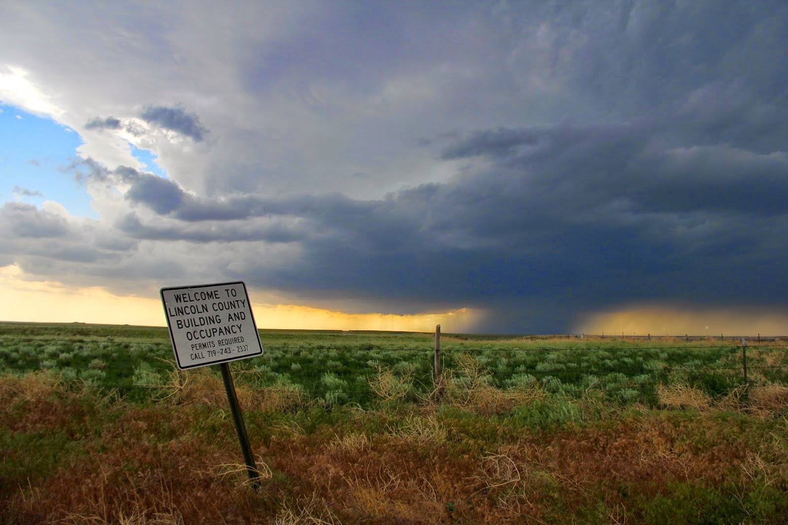
Location: Lamar,
Colorado

13:17z (7:17am
MDT) I wake up .
14z (8:00am MDT)
Forecast Discussion. The setup today will be similar to yesterday in eastern
Colorado except possibly an earlier initiation of convection. (yes!) A slight
risk for severe weather for our area and a 2% chance of tornadoes is given by
SPC. Better chance for tornadoes in Oklahoma, but it's a very long drive and
those storms likely will not initiate until near sunset time anyways.
16:30z (10:30pm
MDT) We leave the hotel and monitor the weather while in Lamar.
17:20z (11:20am
MDT) NWS in pueblo is observing less clouds over the area than forecasted so instability
may be greater today than expected.


17:48z (11:48am
MDT) – After spending some time in Willow Park in Lamar, we leave for lunch at
Becky’s
19:10z (1:10pm
MDT) we leave Becky’s and head to Shell for some gas.
19:20z (1:20pm
MDT) I see what I believe was a scorpion outside of the gas station.
19:27z (1:27pm
MDT) We leave the gas station and head north on 287
19:40z (1:40pm
MDT) We pass Wiley, Co heading north on 287
20z (2:00pm MDT)
We pass Eads, CO , continuing north on 287

20:35z (2:35pm
MDT) The SPC says 95% chance for tornado watch issuance for our area.
Convection is beginning to blossom on radar. Our plan is to head towards Limon,
CO because of the decent location to where the storms are expected to initiate
and the good road system.
20:38z (2:38pm
MDT) We pass Wild Horse, CO on 287
20:49z (2:49pm
MDT) We are now under a severe thunderstorm watch
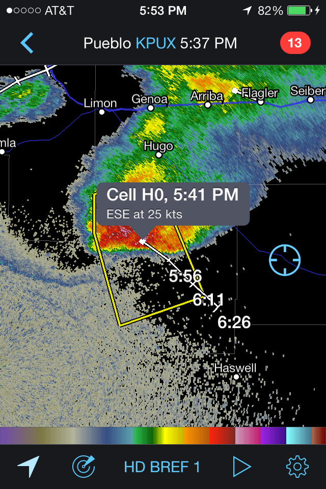
20:51z (2:51pm
MDT) Rotation is detected by radar on the cell just north of Kiowa, CO about 60
miles to our northeast. VIL is 37 but it is close to radar station so not necessarily
completely accurate.
21z (3:00pm MDT)
Passing by some tree damage possibly from yesterday's storms.
21:02z (3:02pm MDT)
Wind gusts with cell near Kiowa is 60mph and VIL is 41.
21:05z (3:05pm
MDT) A severe thunderstorm warning is issued north of Kiowa, CO. Wind gusts of
63 mph and hail was half- dollar according to radar estimates.
21:13z (3:13pm MDT)
We see some distant mammathus clouds. Storm is heading towards Limon, our stop.
21:17z (3:17pm MDT)
tops are 29,000ft, VIL is 46
21:22z (3:22pm MDT)
1 inch hail is recorded 8 miles north of Kiowa, CO.
21:25z (3:25pm MDT)
We enter Limon for a restroom break


21:35z (3:35pm
MDT) We head south on 71.
21:40z (3:40pm
MDT) I see a VIL of 80 on radar scope. Very impressive hail core in the storm
to our northwest.
21:42z (3:42pm
MDT) We hear a weather alert on the radio for a severe thunderstorm warning
with the cell moving west at 20 mph. We stop a few miles south of Limon to
observe the storm.
21:55z (3:55pm
MDT) We are feeling chilly inflow winds. Observation is 72/49

22:05z (4:05pm
MDT) The storm is beginning to move southeasterly and tap into more moisture.
We are in its path and must head south. A storm near the Colorado/New Mexico
border is heading northeast so they may interact in the future.
22:17z (4:17pm
MDT) We move south to avoid falling into the path of the storm, which is
turning south
22:30z (4:30pm
MDT) We stop now, still in the path of the storm, but farther way. Observation
of 76/50 at 4:34
22:39z (4:39pm
MDT) elevated TVS on radar. Feeling a lot of dust from inflow (hurts my legs
more than you’d think). Unlike the dust storm we faced
22:48z (4:48pm MDT)
Storm no longer showing a TVS. A lot of in flow dust so we are departing now.
Dust all over my eyes. Unlike the dust storm we went through on Sunday, this is
going into the storm and is not dominated by out flow winds (which are a sign
of a weakening storm).
22:56z (4:56pm
MDT) We head east on 94.
23:20z (5:20pm MDT)
We make another stop to view the storm. Elevated TVS seen for the last 7 radar
scans (about 14 minutes). A new severe t storm warning is issued for a cell
directly west of us
23:27z (5:27pm
MDT) We leave our spot.
23:33z (5:33pm MDT)
Observation of 74/51

23:40z (5:40pm
MDT) We stop to look at the lowering but nothing happens yet. Storm seems to be
splitting up. We have a good view of the north and south cell and the updrafts
and downdrafts that are beginning to separate them. South cell is the one with
the mesocyclone.
23:45z (5:45pm
MDT) We turn onto 287, heading south, retracing our route from earlier today
except now heading south instead of north!

0z (6:00pm MDT) Elevated
TVs still present at 10,000 feet but not a radar detected meso-cyclone yet.
0:02z (6:02pm MDT)
2 elevated TVs now on the same cell. We see scud where the tornado would be,
but nothing too meaningful yet
0:20z (6:20pm MDT)
The elevated TVs dissipated but it has now redeveloped!
0:29z (6:29pm MDT)
Echo tops are over 50,000
0:35z (6:35pm MDT)
We stop to observe the storm
0:43z (6:43pm MDT)
Tornado warning issued for our cell.


1:02z (7:02pm MDT)
We leave our spot while the storm recycles. Higher clouds are moving one way
and lower clouds another so we do have at least broad rotation. The storm is
gusting out but it can definitely still strengthen. Tornado warning won’t be
reissued after the current one expires.

1:14z (7:14pm MDT)
After lowering, the VIL is climbing back up. This indicates that the updraft is
growing again.
1.75
inch hail 9 miles northeast of Haswell.
1:34z (7:34pm MDT)
We head farther south from our quick stopping spot to stay out of the way of
the storm.
1:45z (7:45pm MDT)
We leave our spot and head towards Lamar for a rest stop. We are losing daylight
and the storm is moving in our direction.
1:53z (7:53pm MDT)
We are heading south and 10 miles away from the precipitation.
2z (8:00pm MDT) We
leave the gas station and continue south into Lamar
2:05z (8:05pm MDT)
Tornado damage reported in Hasty, only 15 miles west of Lamar according to a
tornado warning issued 8 minutes later from this time. (in theory we could have
seen it from our location, but there was probably a combo of trees blocking the
view and/or rain)
2:08z (8:08pm MDT)
While I had my doubts about this storm producing a tornado despite everyone
else’s enthusiasm, I found a couplet that my red/green colorblind eyes can see
on the latest radar scan I and am hoping if a tornado touches down, we see it
before we lose all daylight (and it doesn’t hit any of the towns around this
area). Hail core on this storm is looking crazy impressive visually and Hail
estimates are 3.25 inches according to radar!
2:11z (8:11pm MDT)
We pass the hotel we stayed at this morning on the left... while still storm chasing
(we should have just stayed there all day hahaha)
2:13z (8:13pm MDT)
A tornado warning has been issued as the storm approaches cities (well towns).
The tornado warning is based on radar scans. We are in Lamar at the moment and
under the tornado warning.
2:15z (8:15pm MDT)
We stop in a Walmart parking lot in Lamar to see if we see the tornado or
rotation. Visibility is poor due to bright and tall store signs in the
direction of the storm and lack of daylight.

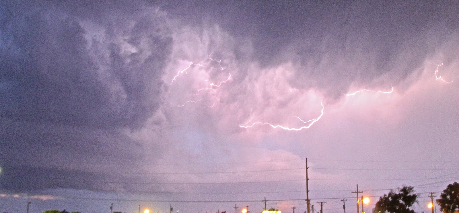
2:53z (8:53pm MDT)
We wait out the storm in the Walmart parking lot after taking some nice
lightening pictures outside. The storm has slowed down significantly and the
couplet is 10 miles to out west southwest direction.

3:05z (9:05pm MDT)
We find a lost dog in the Walmart parking lot. Mike Lee spots it, Sherilyn and Ryann walk out to comfort it, and
then we all comfort the dog until the owners come back.

3:10z (9:10pm MDT)
The owners come to take their dog back home.
3:16z (9:16pm MDT)
We stop at Shell for some gas.
Approx 3:20z (9:20pm
MDT) We take 385 east outside of Lamar and towards Garden City, Kansas.
4:18z (10:18pm
MDT) We enter Granada, CO continuing west on 400 (still the Santa Fe Trail)
Approx 4:30z (10:30pm
MDT) We enter into Kansas.
Approx 5:10z (11:10pm
MDT) We arrive at the Sleep Inn in Garden City, KS.
Journal:
Today was a really
long chase day. The storms were really nice, but traveling up and down the same
roads definitely added to it being a long and exhausting day. But it was worth
the exhaustion because despite again missing a tornado that was very close to
our location, we did see a lot great structures. It was very rewarding to find
a lost dog (who ironically ran away because of he was afraid of storms!) in the
Walmart parking lot and the lightening from the storm made for some nice pics
and an awesome experience. Another good chase day, although I think over the
past 2 days we have traveled up and down just about every major road in this
part of eastern Colorado!
No comments:
Post a Comment