Sunday, June 1, 2014
Current time: 1:24am CDT (Monday)
Log:
Location – Sidney,
Nebraska
Today’s storms are
expected to be the best of the chase so far! The ingredients are mostly there.
One of the issues is a high LCL (Lifted Condensation Level) which would lower
our tornado chances, but there is 0-6km shear in the order of the 30s and 40s
for this afternoon in Kansas according to the GFS and NAM models. Which is an
ingredient missing the past 2 days. Cape is around 2000. The hodograph was
going clockwise in the loop which represented backing winds. The backing winds
representing cold air advection could lead to a high precipitation cell so that
would work against us. When the hodograph crosses over itself that area
represents no shear. This could hinder tornadic development, with the loop
representing little shear at the mid-latitudes, but the parts of the hodograph
that were going clockwise representing veering winds would work in favor for
tornado development and shear that would cause a storm to reach super cell
limits. A shortwave trough was
responsible for the storms with the storms forming on a dry line (giving them
some lift).
13z (7:00am MDT) –
I wake up to the sound of lightening in the distance. A few minutes later, it
begins to hail outside with pea sized hail (and even some marble sized hail)
and heavy rain.


14z (8:00am
MDT) - Forecast discussion. We decide to
head to Oberlin, Kansas since they have a good road network. Storms are
anticipated to form south of that according to current forecasts, but some
models this morning trended the storms north into southern Nebraska and eastward
so Oberlin would be a good place. The SPC has this area under a 5% chance for
tornadoes. Oberlin is right on the 5% text (proving that we are basically in
the dead center of the threat area!).
Approx. 14:30z (8:30am
MDT) – We leave Sidney, NE West on I-80


15:40z (9:40am
MDT) – We stop in Ogallala, NE for gas and change our route to avoid a severe
warned cell. We determine winds to be in a Northern direction so we are still
on the moist side of the dry-line (we need to get to the dry side to see some
good storms).

15:53z (9:53am
MDT) – We pass Bolluck, Nebraska. Our thunderstorm from this morning is to our
backs. No temperatures increase or wind shift that would indicate we are
leaving the boundary.
15:54z(9:54am MDT)
–Winds appear to be stationary (indicated by a completely slack flag on a flag
pole. Car reading temperature is now 72F, up from 64F.
15:58z (9:58am
MDT) – Obs. 72F/63F
16z (10am MDT) –
Severe thunderstorm warning for the cell now to our north has been cancelled.
16:14z (10:14am
MDT) – Car temperature reading is 75F and winds are from the southeast.
16:25z – (10:25am
MDT) - Metar report from Imperial airport: 12 knot winds due south air
temperature of 75F and dew point of 63F.
16:24z – (10:24am
MDT) we pass through Imperial, Kansas and make a turn west onto Route 6.
16:35z
– (10:35am MDT) we head south on 61.
16:55z
- We switch into Central time and turn west on Route 34 to head south.
17z
(12pm CDT) – Observation 80F/65F near Benkelman, KS.
17:20
(12:20 pm CDT) – We turn east onto route 36 near Bird City, KS.
17:34z
– (12:34pm CDT) Metar report from airport: 16 knots, gusts at 23 knots, temperature of 26c and dew
point of 17c and direction of 220 which was from the south west.


18z
(1pm CDT) – Observation 82F/68F east of Atwood on Route 36.
18:45
(1:45pm CDT) – Arrive in Oberlin, Kansas for a quick Subway lunch. We spot some fellow storm chasers here!


19:30z
(2:30pm CDT) – Observation 86F/68F at park in Oberlin, Kansas.
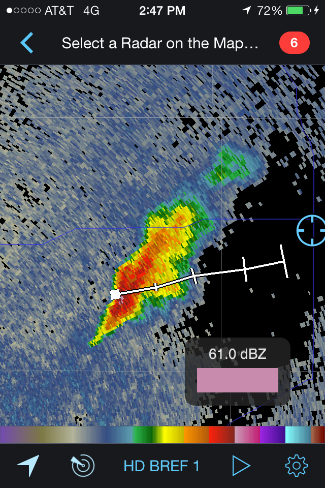
Approx
19:45z (2:45pm CDT) – We leave Oberlin, heading south on Route 83 to move south
of the impressive cell south of Atwood. At 2:27pm CDT Radar indicates a
relatively strong thunderstorm south of Atwood. 61 dBZ for base reflecticity!
19:58
(2:58pm CDT) – Observe our first Mamnathus clouds of the day somewhere a bit
south of Oberlin, KS on route 83.


20:22
(3:33pm CDT) – We drive through Selden, Kansas.
20:38z
(3:38pm CDT) – Observation 86F/68F in … Indicating we are in the moist side of
the dry line. We continue south to catch up with an impressive storm to our
south. The LCLs are high so that is keeping the tornado threat down, but they
are possible!
20:47
(3:47pm CDT) – Observation of 91F/61F at 2047 z.


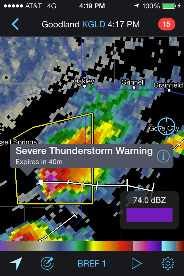
21:08z
(4:08pm CDT) – 20:58z radar scan on my Radar Scope app indicates the storm
south of Russell Springs is severe warned. Vertically integrated liquid is very
high at 74 kg/m^2!
21:09z
(4:09pm CDT) – We make a left turn onto interstate 70 and then a head south on
23 again at the next exit.
21:13z
(4:13pm CDT) – The cell south of Russell Springs is showing some signs of
rotation on radar. A severe thunderstorm warning is in effect until 21z (5pm
CDT) with ping pong sized hail possible and hail as high as 3.25 inches as
indicated by radar. VIL of 80 kg/m^2 and base reflectivity of 74 dBZ

21:17z
(4:17pm CDT) – A severe thunderstorm warning is issued just to the west of our
current location just north of Gove City on 23.

21:26z
(4:26pm CDT) - the 2 storms in the cell we are chasing have now combined into
one with the south cell dominating.
21:43z
(4:43pm CDT) – Dust is seen in the distance being kicked up from winds. We are
just northeast of Healy, KS.
Approx
21:45z (4:45pm CDT) – We head east onto route 4 to stay ahead of the storm.
21:51z
(4:51pm CDT) – We see rain shafts bending in different directions due to
contrasting wind directions at different levels of the atmosphere below the
cloud. This was very interesting!
21:57z
(4:57pm CDT) – We are in the out flow of the storm with visibilities reduced
due to dust.


22:14z
(5:14pm CDT) – most recent radar scan now indicates a clear couplet to the
storm to the east.

22:36z
(5:35pm CDT) – We make a very quick stop and observe a large plume of dust
crossing the road that appears to have some rotation to it. Possibly a
gustnado. Not a tornado, but it certainly looks convincing. We are near Arnold
and Ransom Kansas.


22:40z
(5:40pm CDT) – We observe dust being kicked up from the out flow of the storm.
Temperatures have dramatically decreased and visibilities as we try to move out
are very low at times due to dust. Spotters have reported wind gusts of 60
miles per hour with this storm. The large amounts of dust can be a sign that it
hasn’t rained in a while in this area. More dust than rain could be a sign of
lower precipitation cell or a sign that the storm is dying out if there is a
significant amount of out flow and the storm is not improving on radar in terms
of things like base reflectivity and echo tops. While we did see some dust go
up with updrafts, most of the dust was displaced from the downdraft which
becomes more dominant than updrafts in weakening thunderstorms.

23:06z
(6:08pm CDT) - a Haboob is seen near our current location on 4 just a few miles
west of La Crosse, Kansas.

23:30z
(6:30pm CDT) - We get out of the van to
watch some potential rotation and lowering on the south side of the storm. The
storm looks very impressive and a lot of lightening and dust. Precipitation not
as significant now, but there is still quite a bit of it.

23:47
(6:47pm CDT) – Just as we are heading south on route 123 after stopping, I spot
what is a definite gustnado. We stop and narrowly miss driving into the column
of swirling dust. We drive through the dust settling behind the gustnado and
continue south to Larned, Kansas. We turn east onto 150 to enter Larned which
is a could more miles east for dinner.

00:11z
(7:11pm CDT) We in Larned, Kansas for gas.
Approx
00:20 (7:20pm CDT) We feel the impacts of a quick moving storm.
Approx
00:40 (7:40pm CDT) We eat at Wendy’s.
1:23z
(8:23pm CDT) We see amazing mammatus clouds outside of Pizza Hut and Wendys.in
Larned Kansas.


2:05z
(9:05pm CDT) We leave Lenard for Hays, Kansas taking 156 west.

Approx
2:15z (9:15pm CDT) We turn north onto route 183 and Ryan runs over and severely
injures an innocent raccoon.
3:10
(10:10pm CDT) We arrive in Hays, Kansas and stay at the Super 8 for the night.

Journal:
The
storms today were expected to be severe and they did not disappoint (storms were the first thing I saw when I woke up!). Today taught
me the lesson of how unexpected these storms can be. Although we knew there
would be no hail core, we were affected by the dusty winds from the out flow
boundary which was something that may have been a little bit of a surprise
given the lack of observations in such a rural area and the fact that radar
does not indicate those things directly. The 3 things from today that were most memorable were the early morning storms, the massive amounts of dust while chasing, and the beautiful mamanthus clouds at sunset.The dust was a very new experience for me since I had never been
through a dust storm before and I only remember one thunder storm that kicked
up some dust back home and it was nothing like the dust I saw from this
thunderstorm. While we were in no actual danger and never saw more than drizzle
until we went into town for dinner, I think I learned the lesson today that
things can get bad in a split second and it is important to be far away from
that danger which requires a lot of cooperation from everyone and a lot of
attention for alerts and data. When we have to leave, we have to leave and find
a safer position. The storm today was exciting and incredible. This storm
seemed to be (at least visually) the most convincing storm that could have
produced a tornado since there were a lot of rotations. If the cloud bases were
lower and if the storms weren't destined to become MCS's, I think our chances for a tornado would have been significantly greater,
but that was our limiting factor and it was apparent in the models and in
person as the storms developed.
No comments:
Post a Comment