Current time: 7:00am CDT (Wednesday)
Log:
Location: Topeka,
Kansas.
Today’s forecasted
calls for much more severe weather than any day so far this trip. Thunderstorms
are expected to develop along a warm front because of storms to the north
weakening this morning whose out flow will provide cold air. When that air
interacts with warm air from the south that will give a lot of lift for these
storms. The warm air to the south (as indicated just by looking outside the dew
covered windows of our hotel) is full of moisture and when this combines with
the cold air from the out flow of those storms, the warm air will have nowhere
else to go but up. Most of the ingredients that we look into for thunderstorm
activity are there. CAPE values over central Nebraska will be very favorable
for thunderstorms. Shear is there with values as high as 74 knots (for bulk
wind shear), where CAPE values are in the 2000s (according to RAP and GFS
model) and up to 4000 (according to NAM model) range. The hodograph is very
loopy. Lifted index is about -7 in eastern Nebraska indicating very unstable
air. The LCL heights were forecasted to be a little on the high side around
1000m but that is expected to lower to a more reasonable 500m with current
forecasts.
(12z) sounding in North Platte is similar to
Albany, NY’s back on July 21, 2003 during a tornado outbreak in PA and a
Derecho event in the Hudson Valley
13:00z (8:00am CDT)-
Our goal is to stay south of the warm front so we stay south of storms, which
is why we are taking a lot of readings especially today. Observations will be
critical because wind shifts and temperature changes will give us an idea of
when we are approaching the boundary. The important difference between today
and other chase days is the fact that to the north there will be a huge complex
of thunderstorms that may even become a Derecho. Those won’t contain tornadoes
and if they do, they will be too rain wrapped anyways, but the storms will be
very severe with heavy rain and hail and they will be fast moving too. For this
reason the storms we will chase will be any single cell storms that form south
of this complex since those are what can become super cells and spawn tornadoes
that will be potentially strong and more importantly for our purpose, potentially
viewable.
13:17 (8:17am CDT)-
We leave our Sleep Inn in Topeka Kansas heading west onto I-70.
13:20 (8:20am CDT)
– Observation of 78/70 in Western Topeka. The higher dew points will increase
the CAPE and lower LCL’s in the warm sector of the cold front.
13:30z (8:30am CDT)
– Observation of 78/70 just south of Maple hill on I-70.
- Meso discussion states there is a
40% chance of a watch being issued.
13:45z (8:45am CDT)
– Observation is 78/69 while driving on I-70 just south of St. George.
- York, NE observation: Winds
sustained at18kts gusting to 22 knots from the North. The out flow boundary is
south of this location.
14:00z (9:00am CDT)
– Observation of 82F/68 near Junction City/ Fort Riley, Kansas
14:15z (9:15am CDT)-
Observation of 81/69 near Chapman, Kansas
14:30z (9:30am CDT)-
Observation of 81/69 near Solomon, Kansas
14:39z (9:39am CDT)
– Current model run showing 2 cells around 21z in Nebraska with a north one
around Lorde, NE and a south one around Windor, NE.
14:45z (9:45am CDT)-
Severe Thunderstorm Watch for SD and NE border. We are not in this watch, the watch
is not for our target storms since the storms causing the watch issuance are
hail/rain events mostly.
- We turn north onto 81.
15:00z (10:00am
CDT) – Observation of 82F/69F north of Minneapolis, Kansas.
15:30z (10:30am
CDT) – Observation of 82F/70F southwest of Aurora, Kansas.
15:49z (10:49am
CDT) – We enter Nebraska.
15:52z (10:52am CDT)
– It is getting noticeably cloudier. The boundary is between Geneva and Hebron.
We decide to stop in Hebron for gas and lunch and to monitor the boundary.
15:56z (10:56am
CDT)– We see some towering cumulous while entering into Nebraska that may be
capped which would lead to a collapse and that collapse could provide out flow
to feed larger storms later in the day.
16:00z (11:00 am
CDT) – Observation 82/70 in Hebron, NE.
16:02z (11:02 am
CDT) – Arrive at Shell in Hebron for gas.
16:19z (11:19 am
CDT) – We arrive at Subway in Hebron for lunch.
16:58z (11:58am
CDT) – We leave subway and head back north on 80 to Geneva.
17:00z (12:00pm
CDT) – Observation 82/69 south of Strang, NE.
- Portions of the watch area to the
south and east are being monitored by the SPC for a tornado watch (we are in
this area).
17:23z
(12:23pm CDT) – We arrive at Geneva City Park in Geneva, NE.
18:10z (1:10pm
CDT) – A tornado watch is issued for our area.
18:15z (1:15pm
CDT) - An unconfirmed tornado in Rock County Nebraska.
18:15z (1:30pm
CDT) – We leave Geneva, NE and head south to Aurora, NE (just east of Grand
Island, NE so we can keep up with the boundary that is beginning to move north.

18:57z (1:57pm
CDT) – we turn west onto I-80.
19:00z (2:00pm
CDT) -
Special
sounding for North Platte Topeka and Omaha
For
North Platte…
Cape
is 2500-3000
Mix
layer is 2585
Cap
of 700mb
Storm
relative helicity 575
Observation
82/69 at.>>>>>>>>
19:14z (2:14pm
CDT) – We head north on 14 for Aurora, KS.
19:15z (2:15pm CDT)-
We feel very strong southerly winds (strong enough to push the car a bit). This
will become the in flow for developing storms.
19:20z (2:20pm
CDT) – We arrive in Streeter Park in Aurora, KS.


19:48z (2:48pm
CDT) – Observation 84/71 in Aurora, KS.
20:00z (3:00pm
CDT) – SPC issues a high risk for our area but the risk is for straight-line
winds. Also a 60% chance for severe winds within 25 miles for much of Iowa
because of developing derecho.
19:15z (3:15pm
CDT) - We leave the park in Aurora, NE and continue north on 14to Central City,
NE.
-
Extensive roof damage in Stanton, NE from wind
and hail.
-
Cap has still not been broken but the more air
parcels hit it, the weaker the cap will get and with this environment, it is
likely the cap will break eventually.

20:35z (3:35pm
CDT) – We arrive in Central City, NE.
20:48z (3:48pm
CDT) Observation of 86/72 in Central City Park.
20:52z (3:52pm
CDT) We are hoping for isolated cells south of the main system to our north.
The models are promising. On radar, we can see that a cell is growing near
Lexington that began to exist at about 20:00z(3:00pm CDT). The cell is 90 miles
to our west.


20:57z (3:57pm
CDT) New mesoscale discussion released. Warm front and cold front are coming
close to each other.
21:00z (4:00pm
CDT) The clouds are looking lower to the horizon and a towering cumulous are
beginning to break a cap over us.

21:05z (4:05pm
CDT) - It looks like the tops might be falling down on some clouds over us so
that action could provide out flow, which would result in more lift for other
storms nearby. All that is necessary is for one cloud to successfully break
through the cap.
21:10z (4:10pm
CDT) – A tornado warning is issued for a couplet over Burrell. This is 90 miles
to our northeast.

21:15z (4:15pm
CDT) – We leave Central City for St. Paul, NE, which will put us in a better
position to drive to the Lexington cell if that continues to grow and to the
tornado warned cell near Burrell if the couplet continues to remain promising.
-
Echo tops on Lexington cell (now just south of
Broken Bow) seems to be lowering on radar and the storm is beginning to spread
out.


21:28z (4:28pm CDT) – As we turn left (to head west) on 92, we pass a DOW
(Doppler on Wheels). Sign we are heading to the right place!
(4:30pm
CDT)- VIL of 76 and radar indicated hail size of 3 inches on the tornado warned
cell near Burrell. A tornado is now confirmed from that couplet just north of
Ord, NE.
-
Interesting note, the farm animals always group
close to each other when a storm is nearby.

21:35z (4:35pm
CDT) – The storm that we were watching to our west is by Berwyn and it is
dissipating. There is a storm behind it beginning to form from the out flow of
the dissipating storm so that is something to keep an eye on.
21:38z (4:38pm
CDT) – Dust is being picked up by the in flow winds as we continue to get
whipped around by the in flow winds as we approach the storm.
21:40z (4:40pm
CDT) – Official observation from Ord, NE has winds sustained at 30kts gusting
to 40 kts.

21:48z (4:48pm
CDT) – We are making a right turn onto 281 heading north until we get too close
to the tornado warned storm.
21:50z (4:50pm
CDT) – We pass St. Paul.
21:53z
(4:53pm CDT) – We see a lowering straight-ahead of our current location just
north of St. Paul in our north direction. Might just be in flow clouds.

22:02z
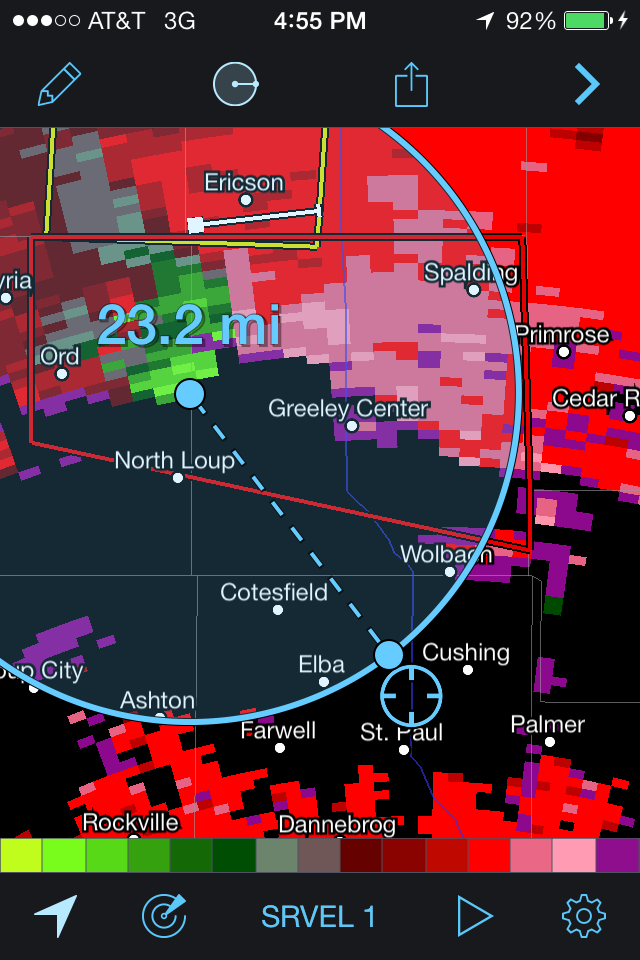
(5:02pm CDT) – We stop to observe the storm on 281 just southwest of Wolbach
and if we cannot get a view we will consider going half a mile further north.

22:05z (5:05 pm
CDT) – A tornado is reported crossing 281 for miles north of where we are at
this time (we found this out a half hour later), but was likely blocked from
our viewing from either the hill ahead, or rain, or both.
22:12z
(5:12pm CDT) – We head back south to avoid the gust front has the RFD movies
closer to us.

22:20z
(5:20pm CDT) – the original couplet is now covered in rain but there is now an
indication of some rotation in the RFD both on radar and in sight.
22:25z
(5:25pm CDT) – We turn east onto 92.
22:30z
(5:30pm CDT) – the latest radar indicates the couplet is 4 miles south of Cedar
Rapids. We still have catching up to do with the storm moving generally east at
50mph-55mph.

22:44z
(5:44pm CDT) – We are still trying to gain on the couplet.


23:00z
(6:00pm CDT) – We decide to bail south next chance because we still only see
some rotation and no funnel cloud. We will chase a cell farther to our west
that has a severe thunderstorm warning.


23:10z
(6:10pm CDT) – We bail south on 81.
23:15z
(6:15pm CDT) – We see rotation on the original tornado warned cell and we see
some dust rotating underneath it! It has not connected.
-
We pass Stromsburg.
23:24z
(6:24pm CDT) – We continue to head south while observing the tornado warned
cell behind us while we move to the next cell.
23:30z
(6:30pm CDT) – A tornado warning for the cell behind us is dropped. We are
heading to a single cell storm near North Platte but that is now beginning to
become a line.

23:45z
(6:45pm CDT) - There is another storm northwest of Gutenberg. Rotation has been
spotted by some tweeters and by radar so that is our next stop. Unfortunately
we are beginning to lose daylight.
-
We turn west onto I – 80.
0:00z
(7pm CDT) – The SPC mesoanalysis shows a new cell north of Lexington weakening
as it moves into an area that is capped. LCL height is 600m and dew point are
lower to the west than east.
0:08z
(7:08pm CDT) – The rotation on the cell near Lexington is weakening and the
storm itself is also showing signs of weakening.
0:11z
(7:11pm CDT) – The SPC meso-analysis says that the base is going to become
elevated and the VIL is dropping so w are going to stop in Grand Island for
some gas and wait and see.
0:15z
(approx. 7:15pm CDT) We arrive in Grand Island. The temperature at the gas
station in Grand Island off of I-80 is only in the 60s.
0:30z
(7:30pm CDT) – We leave the gas station in Grand Island (fortunately without
any sign of our friend who was there the first time we swung by) and head south
on 281.
0:36z
(7:36pm CDT) – We pass the out flow boundary and temperatures very quickly
increase significantly as we pass that leading out flow boundary. There is a
second and stronger out flow boundary from that same storm near Lexington that
is weakening. We are hoping that since the boundary is approaching warm air, it
may provide enough lift to initiate more storms. By 0:55z (7:55pm CDT), the
temperature acc. to the car temperature rose to 85F!. We are trying to outrun
an out flow boundary from the storm that was near Lexington due to high winds
associated with it. Now that the boundary is heading into warmer air, it may
initiate more storms.

0:45z
(7:45pm CDT) - We enter Hastings, Nebraska.
0:51z
(7:51pm CDT) - The out flow boundary is looking interesting and it is the last
chance for more convergence storm initiation. Cumulous clouds are appearing to
bubble up on top of the out flow boundary. We are still under a severe
thunderstorm warning because of the winds expected from the out flow boundary.
-
We head west onto 6.


1:06z
(8:06pm CDT) 73 mph winds were reported in Hastings due to the gust front from
the out flow boundary.
-
We turn south onto 14.
1:07z
(8:07pm CDT) - The shelf cloud still looks very impressive. This boundary is the
cause for us to be under a rare wind related severe thunderstorm warning.


Approx 1:50z (8:50pm CDT)- We ate dinner at a Subway in Superior, NE and are now
seeing lightening to our east from a storm near Beatrice, KS. The storm is
about 60 miles away and is tornado warned.
Approx 2:40z (9:40pm CDT) – We leave Superior to head east on Highway 8 to our hotel
for the night.

02:48z
(9:48pm CDT) Ryann almost runs over a second raccoon, the first of 3 more animals
that night.
03:07z
(10:07pm CDT) We pass Chester, NE (on the Kansas/Nebraska border) and head
south on 81.
We
arrive at our hotel in Salina, Kansas late that night.
Journal:
After
a relaxing yesterday, we had a very full day ahead of us today. Today was
filled with a lot of movement all day long instead of our usual sitting and
waiting for storms to fire up since we needed to make sure we were just south
of the boundary and not to the north. There were very strong storms already
present from the start of the day to our north, but those were not our target
since they were a large complex of storms.
We knew today would be a dangerous day for severe weather, but if
individual cells did not fire up south of the main complex, than any tornadoes
that form would not be visible since they would be rain wrapped and/or very dangerous
to get to. Those individual cells would fire up along the boundary and in order
to locate the boundary we relied on our own observations and the observations
we heard on the radio in surrounding areas. I think one of the most memborable
things from today was the sudden temperature drop outside of Grand Island,
Nebraska when we passed through the outflow boundary. Temperatures went from
the 60s to the 80s within just a minute or 2 on the car thermometer. It went
from chilly outside to warm and humid very quickly! Another thing I will take
from today was how close we were to seeing the tornado just north of St. Paul.
We were only 5 miles away from the touch down, but the hill was blocking the
view of the tornado crossing 287 and it’s possible the tornado was also rain
wrapped so we were unfortunately not able to see it. It was also very cool to
be under a severe thunderstorm warning for an area that was not going to be
impacted by the actual thunderstorm, but instead impacted by the dangerously
strong outflow winds from the storm! That’s a thunderstorm warning I never saw
before and being a part of observing that was really amazing. Even though we
did not see a tornado, today was still an exciting chase day. Everyone knew
that today would be a dangerous day for severe weather so being in that
atmosphere was a really surreal experience and an experience I won’t forget.
No comments:
Post a Comment