Friday, May 30, 2014
Current time: 3:00 z (9:00pm MDT)
Log:
Start Location: North Platte, Nebraska
12:20z (6:20am CDT) Wake up for forecast discussion
13:30z (7:30am CDT) Decide that the best chance for storms will be along (or just behind) the boundary front moving into the region. The Shear is high to the west of the boundary and the cape is high to the east but unfortunately the 2 elements were not seen together so we were dealing with either a lot of instability but not enough shear for the storm to last long, or a lot of shear but nothing to “shear” for lack of a better word. The holograph should be loopy in ideal conditions since that would indicate good directional shear. There was some bubbling on the hodograph in towns near Nebraska and South Dakota, but no looping.
14:00z (8:00am CDT) Sherilyn and I lead the first forecast discussion deciding the most favorable shear and CAPE was south central South Dakota and north central Nebraska. The shear was not at super cell values and without good shear, the possibility for tornadoes was slim. There would be a chance for hail and lightening with the forecasted instability. Our best plan of action would be to head north to Valentines since there were enough roads to head west from there. The prospect for severe storms was not great today but the outlook looked much better for tomorrow so position for those storms were an important consideration of ours and in Valentine we would re-evaluate the data.
Approx 14:30z (8:30am CDT) – Leave North Platte heading north on I-83


Approx 14:45z (10:45am CDT) – Enter Valentine, Nebraska and stop for gas. We then head to a local park to relax and wait until lunch. Temperatures were comfortable with some humidity.


Approx 17z (12pm CDT) – Eat lunch in town.
17:55z (12:55pm CDT) – Finish our lunch. Temperature was officially 86F so it was getting quite warm. Still very sunny.

(20:55z) Observation of 73/62
We head back to the park to wait for some convection to start.
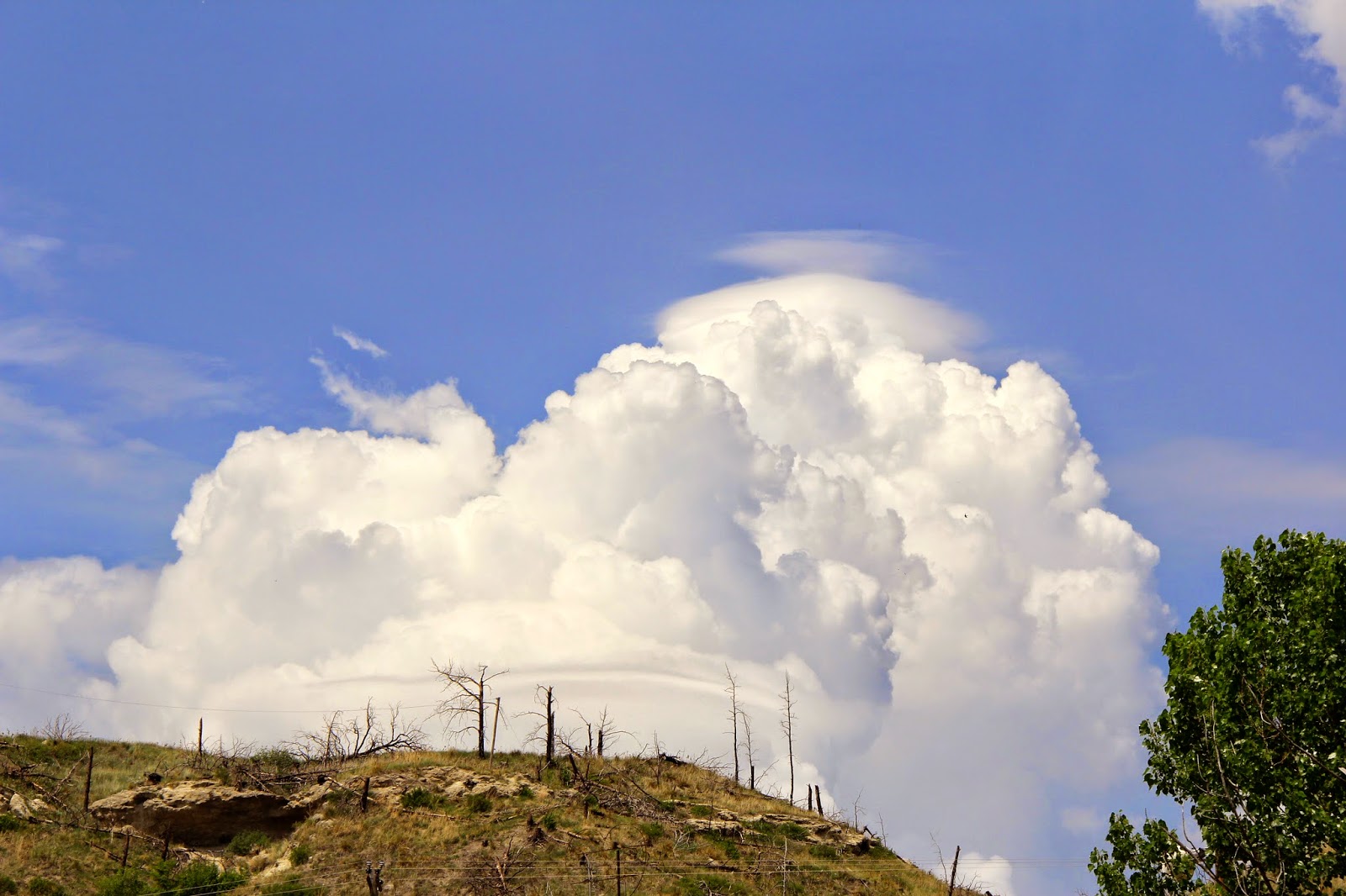
Approx 18:30z (1:30pm CDT) – We see some clouds in the distance really begin to bubble up. One cumulonimbus cloud was just beginning to cap off and we had a perfect view of the entire process. We get excited as we look at the radar and see storms fire up just to our west as expected due to the boundary. We decide to chase a storm southwest of Meridan, NE and heading north slowly towards Gordon, stopping for the night west in Chadron.
Approx 19z (2pm CDT) We head west on I-83
Base reflectivities on our cell have 60 dbz indicating heavy rain.
Approx 19:30z (1:30pm MDT) we switch into mountain date time.
The cell we are chasing becomes severe warned. We get excited.
Approx 20z (2pm MDT) We stop in Cody briefly before heading further west on I-83 to Merriman, NE to monitor the storms closer.
Approx 20:30z (2:30 MDT) We make our stop outside of Merriman to monitor the storm.
- Our Cell loses its severe thunderstorm warning but still looks impressive visually. A lot of scud. Some lightning. Heavy rain shafts, and a decent hail core.


Approx 21z 3pm MDT We head east on I-83 back to Cody to avoid getting brushed by our cell.


Approx 22:30z (4:30pm MDT) – We decide that the storms are not worth continuing to chase for the day because they are weakening. We shop at a store in Cory to kill time as the cell we were chasing passes over I-83.
0:15z (6:15 pm MDT) – We stop in Hay Springs for dinner at a Bar J Steakhouse.


1:15z (7:00 pm MDT) – We continue west onto I – 83 to Chadron.
2z (8 pm MDT) – We arrive at the Best Western in Chadron, Nebraska.
Journal:
Today was our first chasing day and it was my first forecasting day. Valentine, Nebraska was a beautiful little town with an amazing park. We realized the importance of being careful what we say in front of people. I looked at the town’s history and saw that much of the town was damaged by thunderstorm winds in July 2005 and a fire destroyed parts of town 12 months later in 2006, some of the aftermath was still evident. The hill outside of the park was almost completely burned down and there were signs on the hiking paths to watch out for trees weakened by fire. After being distracted a bit by the charm of a small town, we quickly went back into weather mode once we saw the towering cumulonimbus clouds in the distance. It was very impressive to see the capping of the cumulonimbus clouds before our eyes and very interesting to see parts of the cloud bubble up beyond the cap (break the cap). We found our first storm and listened carefully to the weather radio. Once the alert siren went on, and a severe thunderstorm warning was issued for our cell, we all got very excited. It was a great feeling to be in the best spot for storms even if those storms weren’t too impressive. Radar indicated very impressive rainfall rates and some hail as well with large echo tops. Unfortunately the storm, as forecasted, did not have the shear to stay together and began to weaken. The severe thunderstorm warning was cancelled but the storm was still producing heavy rain and some hail. We headed back to Cody to avoid getting hit by the storm and went to a small and very clean student run storm. I talked to a local woman in town who was getting pepper for dinner about the small town of Cody (only a population of 150 people!) and the weather around there throughout the year. After spending a little time in Cody we headed west to Hay Springs for dinner. This was the only restaurant in the entire town and it was only open in the late afternoon. The flat iron steak was great! After that we drove farther west to Chadron for the night. The best western was pretty nice. Matt, Ryann, Claudia, and I went for a walk down the road for some exercise and exploring. We went to a Walmart, got some white chocolate Reese’s and went back to the hotel to relax and go to sleep.
No comments:
Post a Comment